6 Best Places to Go for Summit Hike Views in West Midlands
Sian Victoria © - Malvern Hills, Worcestershire
Walking Trails, Hills, Peaks, Summits Near Birmingham
When reflecting on adventures experienced on my doorstep, my fondest memories revolve around exploring some of the best walking trails and nature reserves in the West Midlands region. From the arrival of spring to the peak of summer and the golden hues of autumn, we embarked on hiking adventures to local destinations, seeking nothing less than beautiful panoramic views.
Hiking has always been a passion of mine. As some of you may already know, I've conquered the Montserrat Mountains in Spain, trekking through the rugged terrain of a still-active volcano in Santorini, marvelled at the awe-inspiring Grand Canyon in Arizona, explored the wonders of Red Rock Canyon in Nevada, ventured up China's magnificent Mount Qingcheng, and conquered the Mount Srđ Trail in Croatia. However, I had never ventured into the fantastic hiking spots right on my doorstep, all within a 30-minute to one-hour drive from my home.
So, here's a list of highly recommended destinations that offer a refreshing escape and a chance to embrace the beauty of the great outdoors. These trails feature easy-to-moderate summit peaks, showcasing the stunning British countryside. I'll continue to update this list as I tick off more from my local adventure bucket list. But for now, here are my top-rated hiking destinations to explore in Birmingham and the surrounding West Midlands:
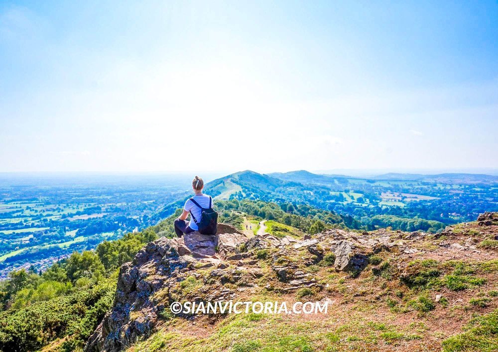
1. Malvern Hills - Worcestershire

Sian Victoria © - Sunset at Malvern Hills, Worcestershire
Sian Victoria © - Malvern Hills, Worcestershire

Sian Victoria © - The Abbey Hotel, Great Malvern
Sian Victoria © - Malvern Hills, Worcestershire Beacon
Sian Victoria © - Malvern Hills, Worcestershire Beacon
The Malvern Hills, also known as the Malvern Hills Area of Outstanding Natural Beauty, is a national reserve with picturesque views from a range of summit peaks. This popular hiking destination is in the English counties of Worcestershire, Herefordshire, and a little bit of northern Gloucestershire. It’s a lovely natural landscape made up of hills, woodlands, and fields. Perfect for walking, enjoying a picnic, biking, and nature photography.
When we visited last summer, we paid to park at one of the many car parks surrounding Malvern. We had no plans or maps. We simply let our feet follow the views. We stopped for a break once we made it to the first hill and then continued walking while taking lots of scenic photos along the way until we reached the Worcestershire Beacon.
The Beacon is the highest point of the range, with an elevation of 1,394 ft. If you were to explore the entirety of the Malvern, you would find 22 hills. On our way down, we stopped at St. Ann's Well, which is a historic café. To complete the day, we strolled the streets of Great Malvern and admired the stunning architecture of The Abbey Hotel and the oldest church in Malvern, the Malvern Priory.
2. The Wrekin - Telford, Shropshire

Sian Victoria © - The Wrekin, Shropshire

Sian Victoria © - The Wrekin, Shropshire

Sian Victoria © - The Wrekin, Shropshire
The Wrekin is a mountain peak located in Shropshire, just five miles from the well-known Ironbridge in Telford. It has an elevation of 1335 feet, offering sweeping vistas of the surrounding landscape. This popular landmark is the perfect place to experience country walking trails.
Depending on your fitness level and which route you take, I’d say it’s a moderate hike, and it can take up to an hour to walk to the top, with beautiful sights to see along the way. We visited on one of the hottest days at the weekend, so it was very busy, and the heat made it a bit more strenuous. However, I’ll undoubtedly be visiting again this spring or early summer. But I will opt to go during the week when it's less busy.
The views from the summit are fantastic. Friends who have been at the top during sunset and sunrise have shown me some incredible photos.
3. Carding Mill Valley and Long Mynd - Church Stretton

Sian Victoria © - Carding Mill Valley reservoir, Shropshire Hills

Sian Victoria © - Carding Mill Valley reservoir, Shropshire Hills
Within a 40-minute drive from the Wrekin, you’ll find the picturesque and historic market town of Church Stretton. Home to Carding Mill Valley and Long Mynd. It’s another beautiful place for exploration in the Shropshire Hills that’s a must-visit for all who love a scenic view and a stroll among nature. It’s also owned by the National Trust, so you’ll find a café at the bottom.
We paid to park at Carding Mill Valley car park and followed the main path to reach the Carding Mill Valley reservoir, which had a tower that people were jumping off to swim. The reservoir is located on a hilltop, so it is a popular spot for sunbathing and swimming during the summer. You’ll find the highest elevation of 1,693 ft above sea level at Pole Bank, Long Mynd. Long Mynd is an area of Common Land where farmers, from generation to generation, have been grazing sheep and ponies on the plateau land.
There’s also the Lightspout Waterfall to see if it’s been raining enough days before your visit.
4. Peak District National Park - Derbyshire

Sian Victoria © - Peak District National Park, Ashbourne

Sian Victoria © - Peak District National Park, Ashbourne

Sian Victoria © - Peak District National Park, Ashbourne
At the Peak District National Park, you’ll find the 5th highest peak in England at Kinder Scout. Which is a moorland plateau and nature reserve at 2,087 ft above sea level.
The National Park spans parts of four geographical regions: East Midlands, West Midlands, North West, Yorkshire, and the Humber. Making it centrally located in England and spanning more than 550 square miles.
The Derbyshire Peak District is the perfect natural landscape for walking, cycling, rock climbing, camping, water sports, caving, and paragliding. As there are so many things to see in Derbyshire Peak District and nearby, we were thankful for our stay at Landal Sandybrook lodges in Ashbourne, where we had a place to relax after all the walking.
If you’re visiting near the Peak District for the day. Then, two of the most popular excursions on the Midlands side of the park are the Dovedale Stepping Stones, which can be found along the River Dove at the foot of Thorpe Cloud. And Thor's Cave in the Manifold Valley of the White Peak in Staffordshire, near Ashbourne.
5. Lickey Hills Country Park

Sian Victoria © - Playground at Lickey Hills Country Park, Birmingham

Sian Victoria © - Lickey Hills Country Park, Birmingham

Sian Victoria © - The top of Lickey Hills Country Park, Birmingham
Recommendations 5 and 6 can be completed on the same day as they are within a 15-minute drive of each other. We always start at Lickey Hills Country Park, located 10 miles southwest of Birmingham. The park has ancient trees and is one of the oldest parks managed by the Birmingham City Council.
Covering 524 acres, here you will find a children’s playground, a café with outdoor seating, scenic views from the hilltop, and wooden sculptures. There are a variety of woodland walking trails and 380 species of flowering plants to see. Sadly, a lot of the ancient trees are having to be cut down because harmful spores have infected them. So, it is advised to stick to the designated paths to prevent the spores from hitching a ride on the bottom of your shoes and spreading elsewhere.
Nearby the Lickey Hills Country Park, you’ll also find a historical landmark, the Beacon Hill Toposcope. Which is a castle on a hilltop 298 meters above sea level with 360-degree views. It does have a car park a short walk away. However, there is a scenic trail you could walk to get there from Lickey Hills, which is on my list to do this year.
6. Clent Hills

Sian Victoria © - The Four Stones, Clent Hills, Worcestershire

Sian Victoria © - Clent Hills, Worcestershire

Sian Victoria © - Clent Hills, Worcestershire
After a stroll around Lickey Hills, go on a short drive to Clent Hills. There’s parking, a café and toilets at Nimmings Wood (B62 0NL) and another car park on Walton Hill Road (B62 0NQ).
We have always entered via Nimmings Wood as the facilities can only be found there. Here, you’ll find the option to hike steep woodland steps or take the designated path up to the hill, which is more suitable for pushchairs and wheelchairs. There’s also a Natural Play Area and a meadow ideal for a picnic. Understandably, like all woodland areas like this, please don’t take a BBQ.
Clent Hills is a large area of beautiful countryside on the outskirts of the city with an elevation of 315 m. On a clear day, it is possible to see the Welsh Black Mountains on the horizon. The National Trust manages the area and is open from 10 am-4 pm every day. If you come by car, make sure you leave in time, as your car will be stuck for the night.
On the top of Clent Hills, a toposcope can be found identifying the historical landmarks that can be seen on a clear day as well as the mysterious Four Stones Megalithic folly. Other historical landmarks in the West Midlands that can be seen nearby are the Wychbury Obelisk and Hagley Castle.
To conclude
So, there you go. These are just a few of the best places to walk in the West Midlands area. Whenever I visit something new, I add it to the list. Let me know if you have any recommended hikes in the region offering panoramic views I should explore.
If you feel inspired to explore one of these incredible hiking trails, make sure you have suitable clothing and footwear first. To get your hands on the best quality outdoor clothing, shop at places where you can save money. For instance, there are Regatta discount codes that you can use to see you through all weathers and terrains so you can focus on enjoying the beautiful summit views.
So, there you go. These are just a few of the best places to walk in the West Midlands area. Whenever I visit something new, I add it to the list. You can also find my hiking videos on YouTube to see other places I’ve hiked recently. Let me know if you have any recommended hikes in the region offering panoramic views I should explore. If I feel they are worth visiting, I’ll add them to this list of walking spots.


